Safentura

Outdoor safety in Wallonia

Hunting closures in Wallonia

Hunting activity can temporarily affect access to forests, paths and public routes in Wallonia. This page explains how official hunting signage works, what red and yellow notices mean, and how Safentura can help you check available closure information before and during your route.

Safentura currently provides hunting closure information for Wallonia. Official signs, barriers and instructions encountered on site always take precedence over digital information.

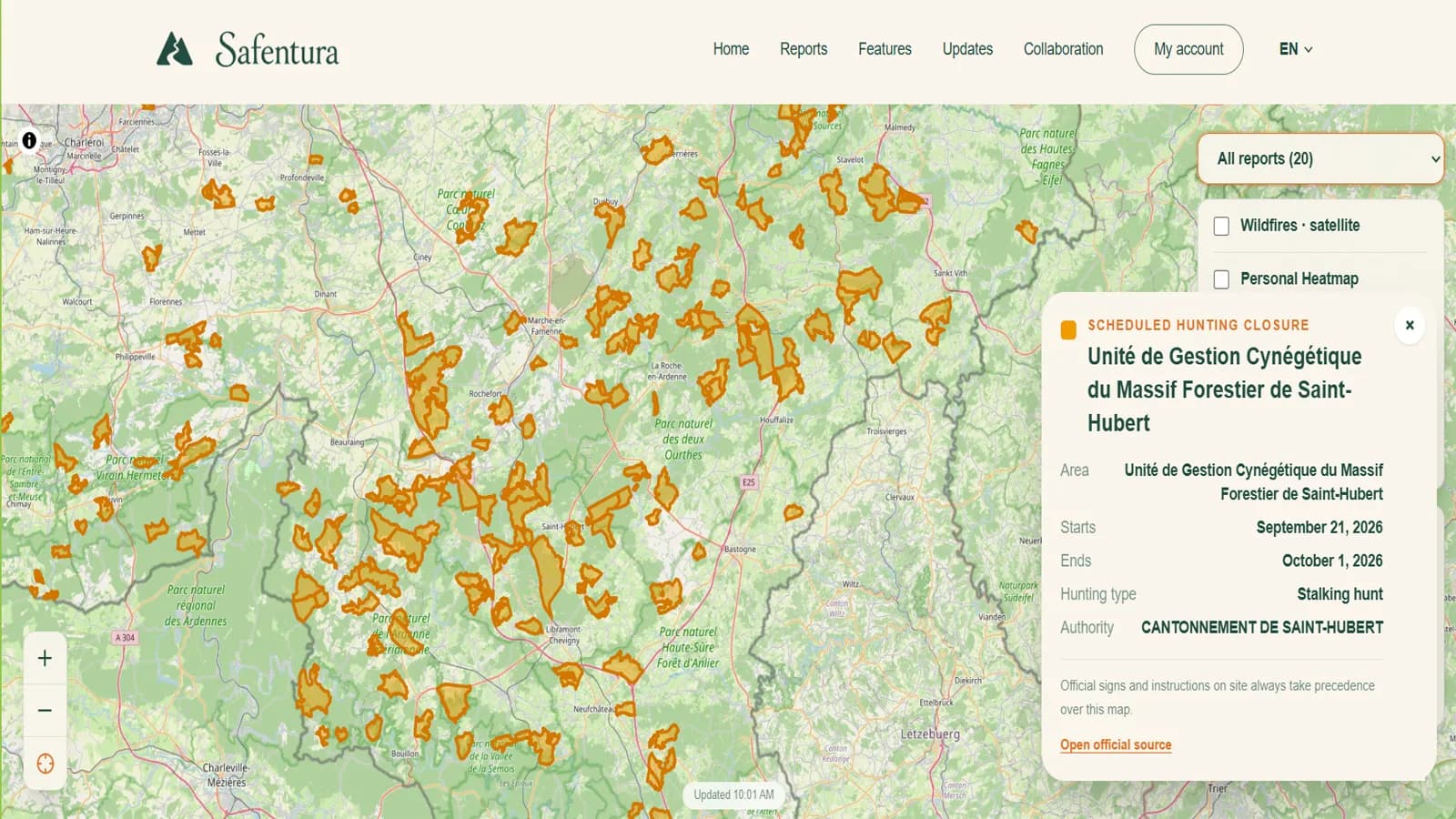
Safentura web map showing hunting closure areas in Wallonia

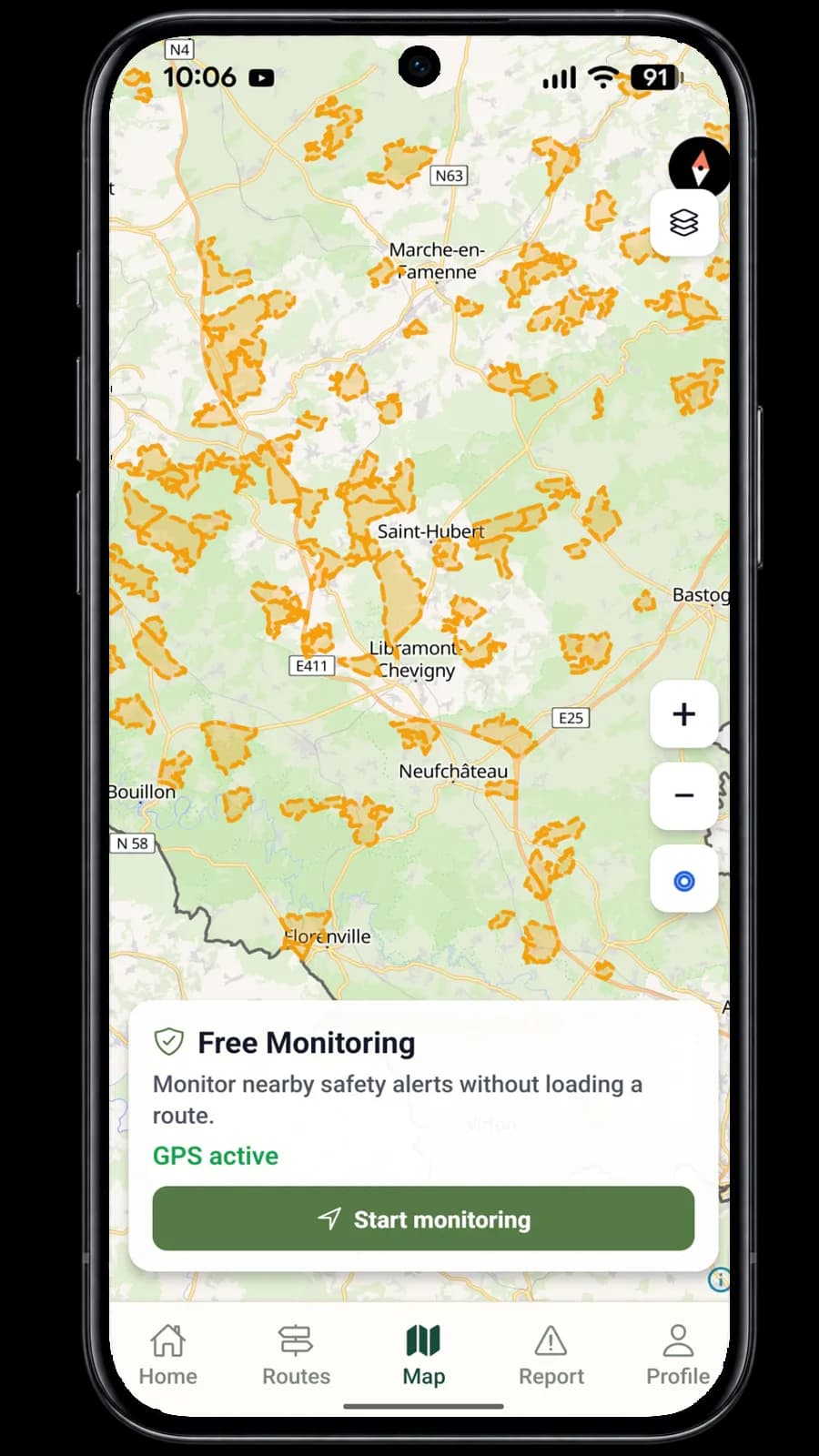
Available hunting closure information can be checked on both the Safentura web map and in the mobile app.

Understanding forest access

Hunting activity does not automatically mean that every forest route is closed

In Wallonia, circulation in forests may be limited or prohibited for safety reasons during hunting activities such as driven hunts or stalking and stand hunting. A closure is a specific measure that applies to a defined place and period. This is why it is important to distinguish between information announcing hunting activity and an official restriction that prohibits access.

01

Hunting activity

A hunting activity may be taking place in an area without every public route being closed. Visitors should remain attentive to official notices, barriers and any additional instructions displayed at the entrances to the affected area.
02

Temporary closure

Where hunting activity creates a safety risk, circulation can be limited or prohibited for a defined location and period. Official closure signs must be placed at the relevant access points and must be respected.

Do not assume that a route is open simply because it appears on a map or because you have used it before. Always check the signs and conditions present when you arrive.

Official signage in Wallonia

Learn to recognise the signs before entering a forest area

Wallonia uses official hunting notices to communicate planned hunting activity and temporary access restrictions. The colour of the notice is important, but the information written on the sign is equally important because it identifies when and where the measure applies.

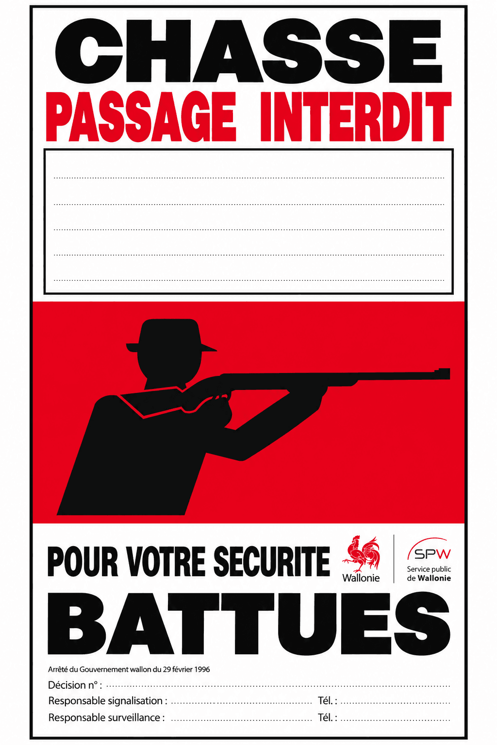
Official-style red Wallonia hunting sign indicating passage prohibited

Access restriction

Red sign: passage prohibited

An official red hunting sign indicates that circulation is prohibited for the place and period specified on the notice. These signs are used where access has been restricted for safety reasons in connection with hunting activity.

If you encounter a red closure sign covering your route, do not continue into the closed area. Choose another route and follow any barriers or additional instructions present on site.

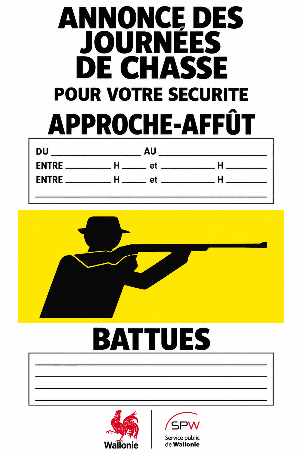
Official-style yellow Wallonia hunting notice announcing hunting activity

Hunting information

Yellow sign: hunting activity announced

A yellow hunting notice warns visitors about hunting activity or announces future hunting days. A yellow sign does not by itself prohibit circulation, but it tells you that hunting activity is relevant to the area and that you should read the dates and instructions carefully.

Remain attentive to the information on the notice and look for any red closure signs, barriers or other restrictions before continuing. Conditions may differ between nearby access points and dates.

The examples shown here reproduce the type of official hunting signage used in Wallonia. The legally relevant information is the sign installed on site, including its location, dates and any authorised restriction.

Read the official Wallonia information →

The most important rule

What you see on the ground takes precedence

Digital maps are useful for preparing a route and understanding where hunting activity or closures may occur, but they cannot replace the official notices placed at forest entrances and along affected public routes. Conditions can change, and the information displayed on site is the information you must follow.

If an official sign, barrier or instruction prevents access, do not enter the area even if Safentura or another map appears to show the route as available.

Safentura hunting information

Check affected areas before starting your route

Safentura displays available hunting closure information for Wallonia directly on the map. Selecting an area allows you to review the information associated with that closure so that you can take it into account when planning a hike, walk, run or cycling route.

Safentura map showing scheduled hunting closure polygons and closure details in Wallonia
01

Affected area

The map shows the geographic area associated with the available hunting closure information.

02

Start and end dates

Where available, Safentura displays the period during which the hunting closure information applies.

03

Hunting type

The closure details can include the type of hunting activity recorded for that area.

04

Responsible authority

Where provided by the source data, the responsible authority or cantonnement is shown together with access to the official source.

Before and during your route

Plan on the web and check again from your phone

The same type of hunting closure information can be consulted on the Safentura website and in the mobile app. The web map is useful when preparing a route at home, while the mobile app lets you check the area again when you are outside.

1

Check before leaving

Review the area you intend to visit and look for scheduled hunting closures that could affect your planned route.

2

Check again in the field

Use the mobile map as an additional source of information while outside, particularly if your route changes or you approach an area you did not originally plan to enter.

3

Always verify the physical signs

When you reach the forest, the official signs, barriers and instructions on site remain decisive. Safentura is designed to support awareness, not to replace them.

Safentura desktop map showing hunting closures in Wallonia
Safentura mobile map showing hunting closures while outdoors

Source information: Service public de Wallonie and SPW Environnement. Safentura does not replace official Walloon signage, decisions or instructions issued by the competent authorities.

Frequently asked questions

Hunting closures and forest access in Wallonia

These answers summarise the practical points that matter most when you are preparing or following an outdoor route in Wallonia.

When in doubt, do not enter.

If the information on a sign is unclear, a barrier is present, or the situation on site does not match what you expected from the map, choose another route rather than entering an area whose access status is uncertain.

01

Does hunting activity mean that the forest is automatically closed?

No. Hunting activity and a formal access restriction are not the same thing. In Wallonia, circulation may be limited or prohibited for safety reasons in defined areas and during defined periods. You should check the official signage at the relevant access points rather than assuming that the entire surrounding forest is closed.

02

What does a red hunting sign mean in Wallonia?

A red official hunting sign indicates an access prohibition for the place and period specified on the notice. If your route enters the area covered by that restriction, you should not continue through it.

03

What does a yellow hunting sign mean?

A yellow sign is a warning or announcement relating to hunting activity. According to SPW information, yellow warning signs can announce future hunting days or activity but do not themselves prohibit circulation. You should still read the notice carefully and check whether any additional closure signs or barriers apply.

04

Where can I check hunting closures in Wallonia?

You can consult official Walloon information through ChasseOnWeb and SPW resources. Safentura also displays available hunting closure information for Wallonia on its web and mobile maps so that outdoor users can include it in their route planning.

05

Can I rely only on Safentura to know whether a route is open?

No. Safentura is an additional safety-information tool. It can help you identify available hunting closure information before and during a route, but official signs, barriers and instructions encountered on site always take precedence.

06

What should I do if the map and the signs on site do not match?

Follow the official signs and instructions on site. SPW explicitly states that digital hunting information does not replace warnings placed in the field. If access is prohibited on the ground, do not enter the area even if the digital map appears different.

07

What should I do if my planned route crosses a hunting closure?

Do not continue through an area that is officially closed. Replan your route around the affected area and verify the alternative access points on site, because a nearby path may be subject to a different restriction or no restriction at all.

Prepare before you go

Check the area, understand the signs and respect the closure

A few minutes spent checking the route before leaving can help you avoid arriving at a closed forest access point or entering an area affected by hunting activity. Use Safentura to review available information, then confirm the situation from the official signs when you arrive.